publications
2026
-
 Semantic urban elements: A Design+Science paradigm to augment human-centric cities?Matias Quintana, Chenyi Cai, Rohit K. Dubey, Javier Argota Sánchez-Vaquerizo, Youlong Gu, Kosuke Kuriyama, Shiying Li, Christoph Hölscher, Aurel Richthofen, Pieter Herthogs, Dirk Helbing, and Filip BiljeckiEnvironment and Planning B: Urban Analytics and City Science, May 2026
Architecture, engineering, and construction have increasingly integrated automated tools and digital approaches for urban analysis and design. Many of these approaches are tailored towards either urban Design or urban Science, despite both being central to our understanding of cities. The separation between these two core aspects of urban development introduces multidisciplinary challenges when addressing the consequences of urban phenomena. We propose the paradigm of Semantic Urban Elements (SUEs) to combine Science-based and Design-based knowledge about potential solutions to complex urban issues, integrating advances in scientific and design thinking about such solutions using formal, open knowledge representation frameworks. We first present current problems by briefly discussing the relevant state of the art in urban Science and urban Design. Second, we derive the key characteristics that a combined urban Design+Science approach would require. We then posit a definition of SUEs and provide an illustrative example, followed by a contextualization of our proposition and evaluate existing work through the lens of our proposed paradigm. The novel SUEs method is an enabling infrastructure that supports iterative, evidence-informed design exploration and transparent evaluation. In this way, SUEs responds to the digital revolution in urban quantification by integrating Design and Science and provides the necessary framing lens to tackle different challenges in cities in a way that benefit cities, humans, and their future, considering their mutual relationships.
@article{quintana_semantic_2026, title = {Semantic urban elements: {A} {Design}+{Science} paradigm to augment human-centric cities?}, issn = {2399-8083}, shorttitle = {Semantic urban elements}, url = {https://doi.org/10.1177/23998083261448244}, doi = {10.1177/23998083261448244}, language = {EN}, urldate = {2026-05-30}, journal = {Environment and Planning B: Urban Analytics and City Science}, publisher = {SAGE Publications Ltd STM}, author = {Quintana, Matias and Cai, Chenyi and Dubey, Rohit K. and Argota Sánchez-Vaquerizo, Javier and Gu, Youlong and Kuriyama, Kosuke and Li, Shiying and Hölscher, Christoph and von Richthofen, Aurel and Herthogs, Pieter and Helbing, Dirk and Biljecki, Filip}, month = may, year = {2026}, pages = {23998083261448244}, } -
 Assessing Park Satisfaction from Google Maps Reviews: Novel Evidence from Multimodal Text–Image AnalysisYoulong Gu, Wenpei Li, Angelia Sia, and Filip BiljeckiThe 34th Annual GIS Research UK Conference (GISRUK), Apr 2026
Parks are essential to urban well-being, making park satisfaction crucial for sustainable city development. Traditional survey-based approaches to understand sentiment towards parks among residents are often costly, time-consuming, and limited in scale. Recent social media–based studies have scaled such research but predominantly focus on text and frequently overlook visual information and the joint effects of text–image representations. This study presents an automated multimodal framework using crowdsourced reviews from Google Maps to model park satisfaction by integrating textual and visual features. Using Singapore as a case study, we analysed 76,869 textual reviews and 184,322 images associated with them. The results show that multimodal models are more useful than text-only approaches, with textual sentiment, emotional attributes, and image temporal characteristics identified as the most influential factors. These findings highlight the importance of multimodal analysis for advancing park research and informing planning and policy practices.
@article{gu_assessing_2026, title = {Assessing {Park} {Satisfaction} from {Google} {Maps} {Reviews}: {Novel} {Evidence} from {Multimodal} {Text}–{Image} {Analysis}}, shorttitle = {Assessing {Park} {Satisfaction} from {Google} {Maps} {Reviews}}, url = {https://zenodo.org/records/19387282}, doi = {10.5281/zenodo.19387282}, urldate = {2026-04-07}, journal = {The 34th Annual GIS Research UK Conference (GISRUK)}, author = {Gu, Youlong and Li, Wenpei and Sia, Angelia and Biljecki, Filip}, month = apr, year = {2026}, keywords = {Urban green spaces, Park perception, Crowdsourced data, Vision-language model.}, } -
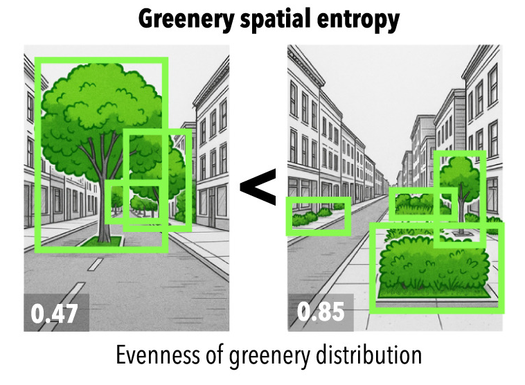 It is not always greener on the other side: Greenery perception across demographics and personalities in multiple citiesMatias Quintana, Fangqi Liu, Jussi Torkko, Youlong Gu, Xiucheng Liang, Yujun Hou, Koichi Ito, Yihan Zhu, Mahmoud Abdelrahman, Tuuli Toivonen, Yi Lu, and Filip BiljeckiLandscape and Urban Planning, Jul 2026
Quantifying and assessing urban greenery is consequential for planning and development, reflecting the everlasting importance of green spaces for multiple climate and well-being dimensions of cities. Evaluation can be broadly grouped into objective (e.g., measuring the amount of greenery) and subjective (e.g., polling the perception of people) approaches, which may differ – what people see and feel about how green a place is might not match the measurements of the actual amount of vegetation. In this work, we advance the state of the art by measuring such differences and explaining them through human, geographic, and spatial dimensions. The experiments rely on contextual information extracted from street view imagery and a comprehensive urban visual perception survey collected from 1000 people across five countries with their extensive demographic and personality information. We analyze the discrepancies between objective measures (e.g., Green View Index (GVI)) and subjective scores (e.g., pairwise ratings), examining whether they can be explained by a variety of human and visual factors such as age group and spatial variation of greenery in the scene. The findings reveal that such discrepancies are comparable around the world and that demographics and personality do not play a significant role in perception. Further, while perceived and measured greenery correlate consistently across geographies (both where people and where imagery are from), where people live plays a significant role in explaining perceptual differences, with these two, as the top among seven, features that influences perceived greenery the most. This location influence suggests that cultural, environmental, and experiential factors substantially shape how individuals observe greenery in cities. We also found that the spatial arrangement of greenery in the sight, rather than its proximity to the person, influences perception. Our study provides a new understanding of the deep relationships between objective and subjective street-level greenery assessments, contributing to a more human-centric design of green urban environments.
@article{quintana_it_2026,
  title = {It is not always greener on the other side: {Greenery} perception across demographics and personalities in multiple cities},
  volume = {271},
  issn = {0169-2046},
  shorttitle = {It is not always greener on the other side},
  url = {https://www.sciencedirect.com/science/article/pii/S0169204626000423},
  doi = {10.1016/j.landurbplan.2026.105618},
  urldate = {2026-03-23},
  journal = {Landscape and Urban Planning},
  author = {Quintana, Matias and Liu, Fangqi and Torkko, Jussi and Gu, Youlong and Liang, Xiucheng and Hou, Yujun and Ito, Koichi and Zhu, Yihan and Abdelrahman, Mahmoud and Toivonen, Tuuli and Lu, Yi and Biljecki, Filip},
  month = jul,
  year = {2026},
  keywords = {GeoAI, Green view index, Pedestrian greenery, Street view imagery, Urban sensing, Urban visual perception},
  pages = {105618},
}
2025
-
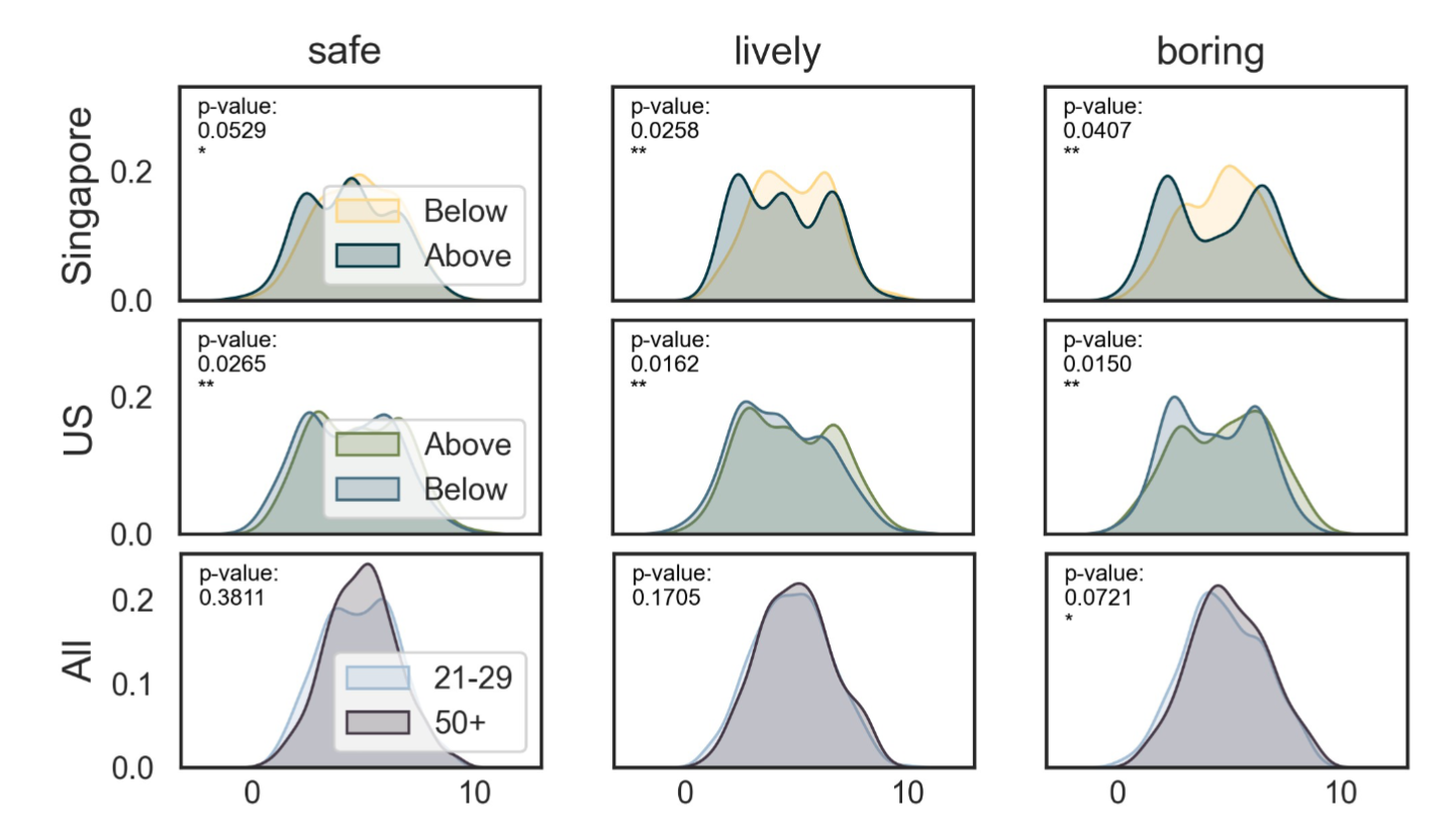
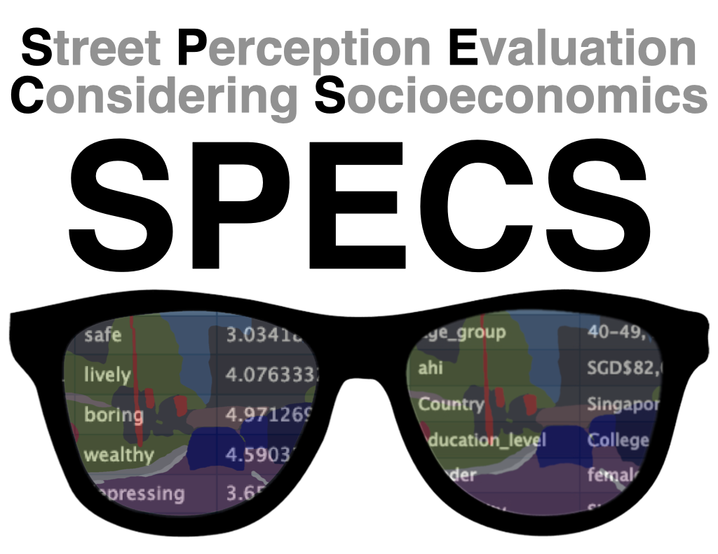 Global urban visual perception varies across demographics and personalitiesMatias Quintana, Youlong Gu, Xiucheng Liang, Yujun Hou, Koichi Ito, Yihan Zhu, Mahmoud Abdelrahman, and Filip BiljeckiNature Cities, Nov 2025
Understanding people’s preferences is crucial for urban planning, yet current approaches often combine responses from multi-cultural populations, obscuring demographic differences and risking amplifying biases. We conducted a large-scale urban visual perception survey of streetscapes worldwide using street view imagery, examining how demographics—including gender, age, income, education, race and ethnicity, and personality traits—shape perceptions among 1,000 participants with balanced demographics from five countries and 45 nationalities. This dataset, Street Perception Evaluation Considering Socioeconomics, reveals demographic- and personality-based differences across six traditional indicators—safe, lively, wealthy, beautiful, boring, depressing—and four new ones: live nearby, walk, cycle, green. Location-based sentiments further shape these preferences. Machine-learning models trained on existing global datasets tend to overestimate positive indicators and underestimate negative ones compared to human responses, underscoring the need for local context. Our study aspires to rectify the myopic treatment of street perception, which rarely considers demographics or personality traits.
@article{quintana_global_2025, title = {Global urban visual perception varies across demographics and personalities}, volume = {2}, copyright = {2025 The Author(s), under exclusive licence to Springer Nature America, Inc.}, issn = {2731-9997}, url = {https://www.nature.com/articles/s44284-025-00330-x}, doi = {10.1038/s44284-025-00330-x}, number = {11}, journal = {Nature Cities}, publisher = {Nature Publishing Group}, author = {Quintana, Matias and Gu, Youlong and Liang, Xiucheng and Hou, Yujun and Ito, Koichi and Zhu, Yihan and Abdelrahman, Mahmoud and Biljecki, Filip}, month = nov, year = {2025}, keywords = {Cultural and media studies, Geography, Psychology and behaviour}, pages = {1092--1106}, } -
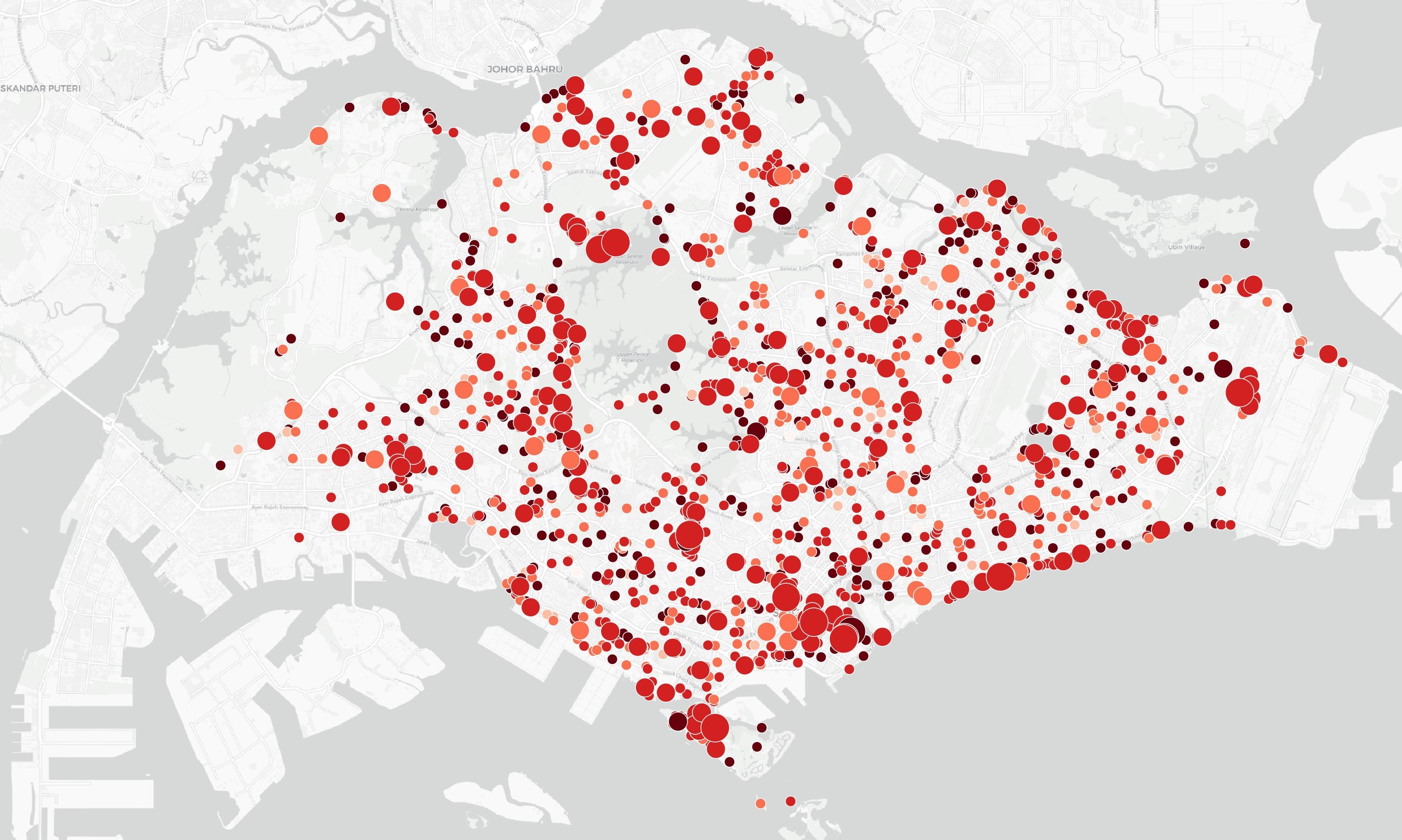
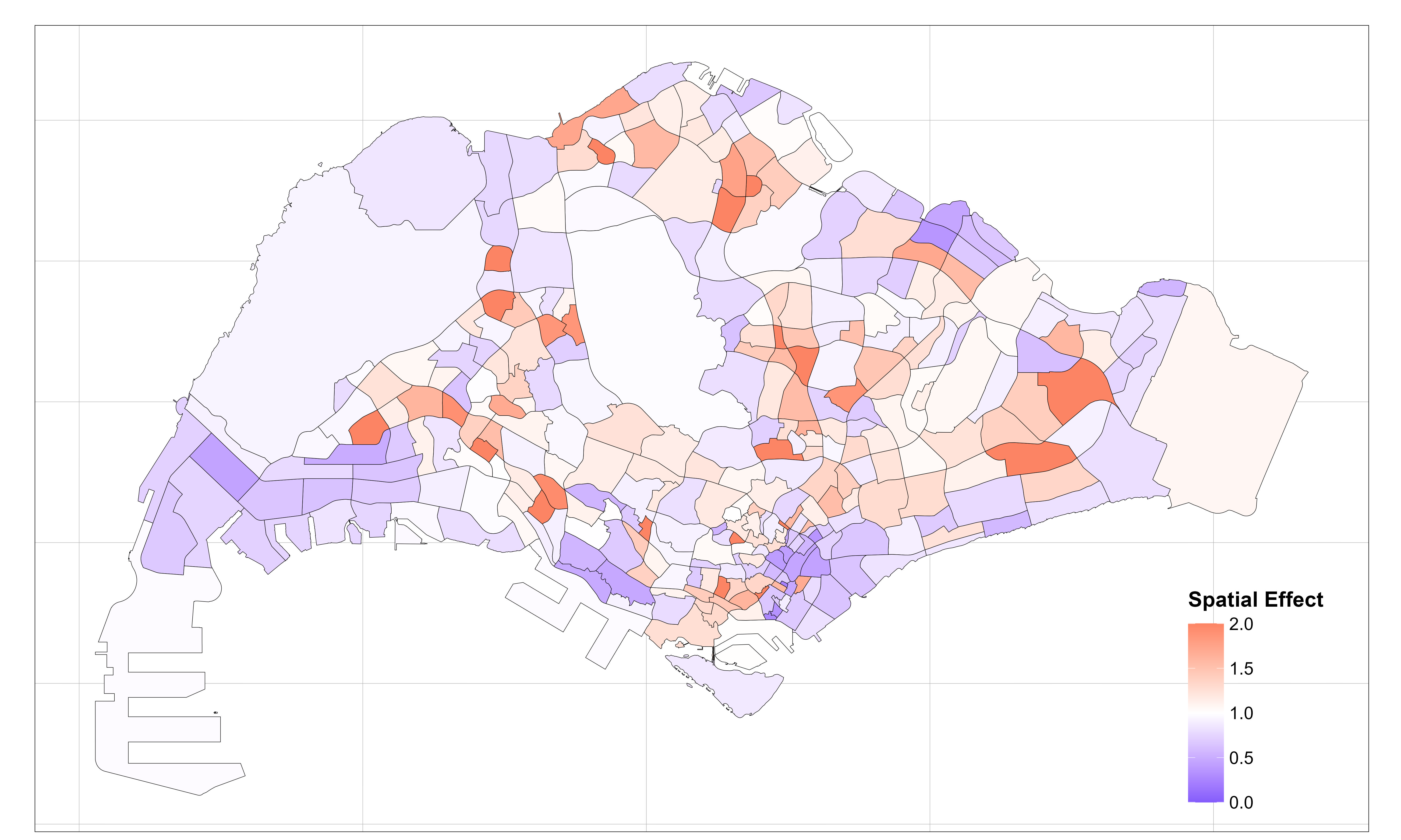 A Bayesian Spatiotemporal Framework for Explaining Bus Ridership Dynamics in SingaporeYoulong Gu, Haixiao Liu, Lingsheng Lan, Yu He, and Filip BiljeckiThe 19th International Conference on Computational Urban Planning and Urban Management (CUPUM), 2025
Bus networks serve as the backbone of urban public transport, significantly shaping daily mobility patterns. However, few studies have leveraged long-term high spatiotemporal resolution bus data to precisely analyze service demand and urban-scale ridership dynamics. This study proposes a Bayesian hierarchical spatiotemporal modelling framework that integrates structured and unstructured spatial and temporal components. Using Singapore —a city with a dense bus network — as a case study, we evaluate the framework’s effectiveness, identify spatiotemporal trends and ridership hotspots, and assess the influence of key spatial covariables. The findings offer valuable insights for urban and transport planning.
@article{gu_bayesian_2025, title = {A {Bayesian} {Spatiotemporal} {Framework} for {Explaining} {Bus} {Ridership} {Dynamics} in {Singapore}}, url = {https://osf.io/abyqh/}, doi = {10.17605/OSF.IO/ABYQH}, journal = {The 19th International Conference on Computational Urban Planning and Urban Management (CUPUM)}, publisher = {OSF}, author = {Gu, Youlong and Liu, Haixiao and Lan, Lingsheng and He, Yu and Biljecki, Filip}, year = {2025}, keywords = {agent-based modelling, artificial intelligence, cloud cities, data ownership, digital infrastructure, digital twin, land use, machine learning, public data, spatial analysis, sustainability, transportation, urban planning, virtual systems}, } -
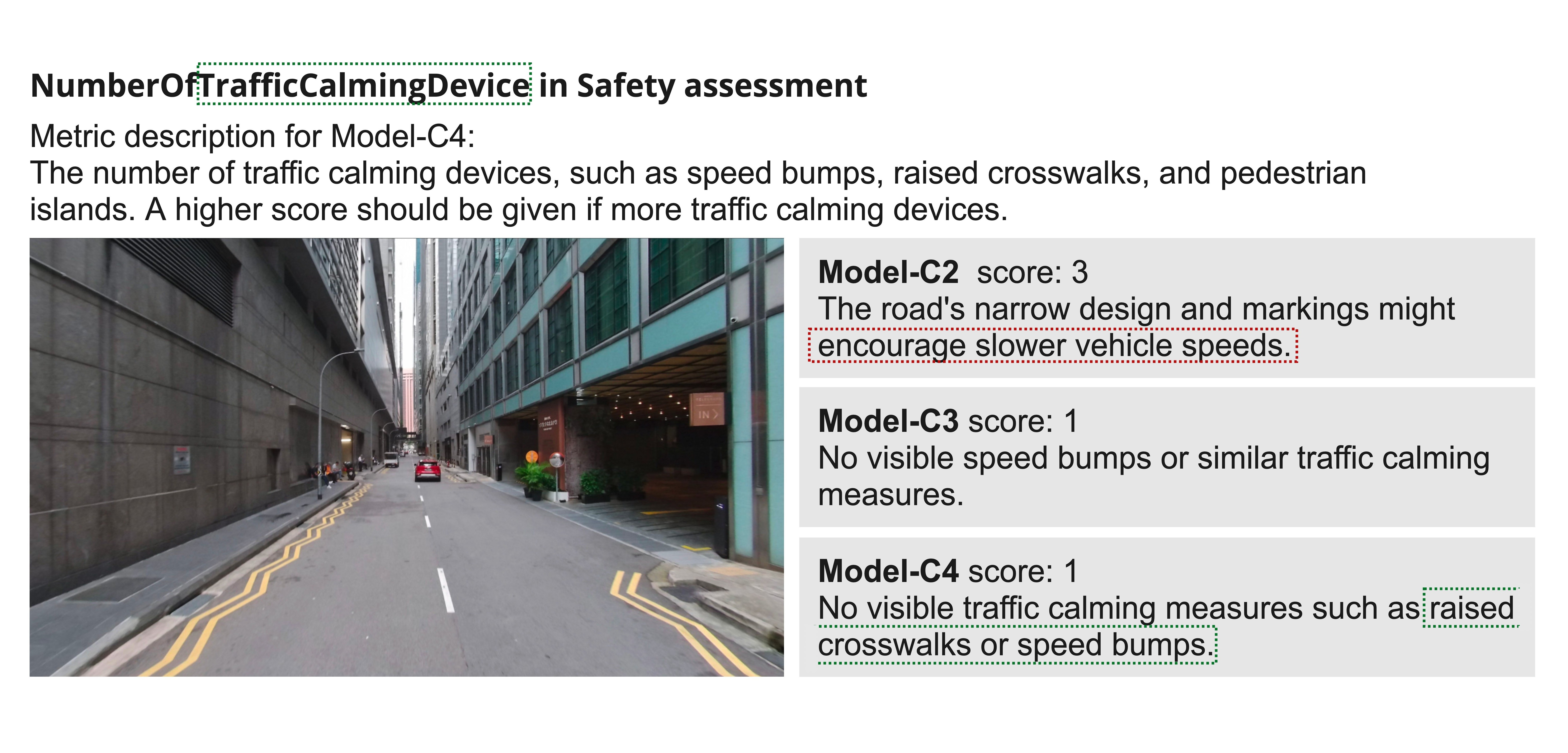 Can a Large Language Model Assess Urban Design Quality? Evaluating Walkability Metrics Across Expertise LevelsChenyi Cai, Kosuke Kuriyama, Youlong Gu, Filip Biljecki, and Pieter HerthogsISPRS Annals of the Photogrammetry, Remote Sensing and Spatial Information Sciences, Sep 2025
Urban street environments are vital to supporting human activity in public spaces. The emergence of big data, such as street view images (SVI) combined with multi-modal large language models (MLLM), is transforming how researchers and practitioners investigate, measure, and evaluate semantic and visual elements of urban environments. Considering the low threshold for creating automated evaluative workflows using MLLM, it is crucial to explore both the risks and opportunities associated with these probabilistic models. In particular, the extent to which the integration of expert knowledge can influence the performance of MLLM in the evaluation of the quality of urban design has not been fully explored. This study set out an initial exploration of how integrating more formal and structured representations of expert urban design knowledge (e.g., formal quantifiers and descriptions from existing methods) into the input prompts of an MLLM (ChatGPT-4) can enhance the model’s capability and reliability to evaluate the walkability of built environments using SVIs. We collect walkability metrics through the existing literature and categorise them using relevant ontologies. Then we select a subset of these metrics, used for assessing the subthemes of pedestrian safety and attractiveness, and develop prompts for MLLMs accordingly. We analyse MLLM’s abilities to evaluate SVI walkability subthemes through prompts with multiple levels of clarity and specificity about evaluation criteria. Our experiments demonstrate that MLLMs are capable of providing assessments and interpretations based on general knowledge and can support the automation of imagetext multimodal evaluations. However, they generally provide more optimistic scores and can make mistakes when interpreting the provided metrics, resulting in incorrect evaluations. By integrating expert knowledge, MLLM’s evaluative performance exhibits higher consistency and concentration. Therefore, this paper highlights the importance of formally and effectively integrating domain knowledge into MLLMs for evaluating urban design quality.
@article{cai_can_2025, title = {Can a {Large} {Language} {Model} {Assess} {Urban} {Design} {Quality}? {Evaluating} {Walkability} {Metrics} {Across} {Expertise} {Levels}}, volume = {X-4-W7-2025}, issn = {2194-9042}, url = {https://isprs-annals.copernicus.org/articles/X-4-W7-2025/1/2025/}, doi = {10.5194/isprs-annals-X-4-W7-2025-1-2025}, journal = {ISPRS Annals of the Photogrammetry, Remote Sensing and Spatial Information Sciences}, publisher = {Copernicus GmbH}, author = {Cai, Chenyi and Kuriyama, Kosuke and Gu, Youlong and Biljecki, Filip and Herthogs, Pieter}, month = sep, year = {2025}, keywords = {ontology, public space evaluation, semantic and visual elements, street view images, walkability assessment}, pages = {1--8}, } -
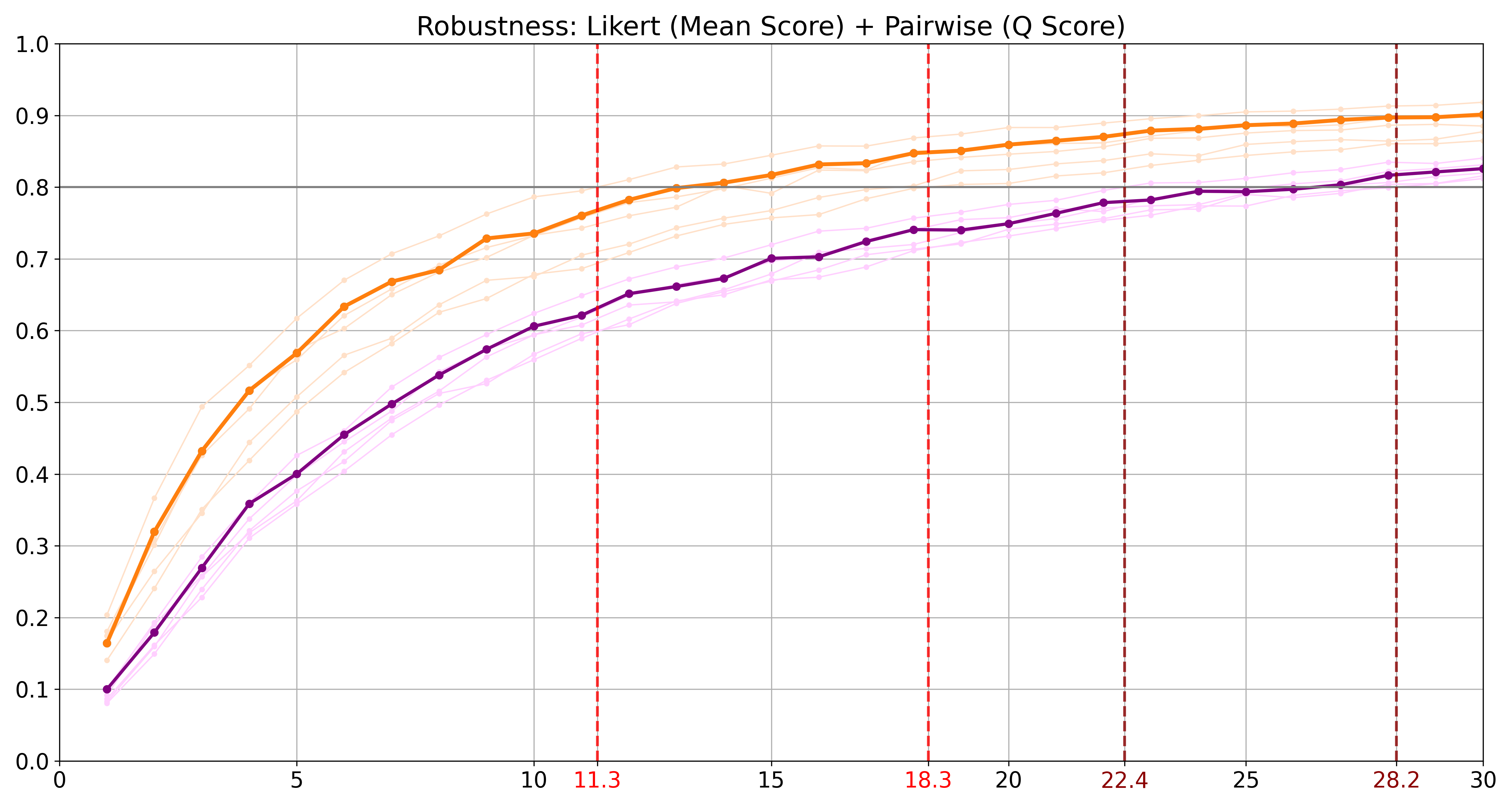 Designing effective image-based surveys for urban visual perceptionYoulong Gu, Matias Quintana, Xiucheng Liang, Koichi Ito, Winston Yap, and Filip BiljeckiLandscape and Urban Planning, Aug 2025
Urban visual perception is important for the human experience in cities, shaped by intertwined characteristics of urban landscapes. By quantifying and explaining these perceptual experiences, researchers can gain insights into human preferences and support decision-making in planning and design. However, past studies have shown inconsistencies in survey design and ambiguities in reporting, leading to concerns about the reliability and reproducibility of results. This study proposes the first comprehensive framework to guide image-based survey design for capturing perceptions of outdoor urban environments across different scenarios, addressing the lack of methodological standardization in current research. We reviewed existing surveys to identify key parameters, conducted comprehensive between-subject and within-subject surveys, and performed statistical analyses to determine best practices for survey design across different contexts. Aiming to set a potential community standard, our study doubles as a blueprint for a reporting protocol for survey designs. Based on the results, we recommend: (1) meeting a minimum of 12 and 22 ratings per image for Likert Scale and Pairwise Comparison studies to reach survey reliability, respectively, and reporting these alongside other survey design parameters to enhance transparency and reproducibility; and (2) when resource allows larger experiments, adopt a ranking method such as Pairwise Comparison to achieve firmer rating results; and (3) using perspective (non-panoramic) images more frequently, as they exhibit comparable overall scores to panoramic images (R mostly \textgreater0.7), while being more widely available via crowdsourced sources, supporting their use in large-scale visual perception research.
@article{gu_designing_2025,
  title = {Designing effective image-based surveys for urban visual perception},
  volume = {260},
  issn = {0169-2046},
  url = {https://www.sciencedirect.com/science/article/pii/S0169204625000751},
  doi = {10.1016/j.landurbplan.2025.105368},
  urldate = {2026-01-17},
  journal = {Landscape and Urban Planning},
  author = {Gu, Youlong and Quintana, Matias and Liang, Xiucheng and Ito, Koichi and Yap, Winston and Biljecki, Filip},
  month = aug,
  year = {2025},
  keywords = {Built environment, Street view imagery, Urban perception, Human participants, Survey parameters},
  pages = {105368},
}
2024
-
 My street is better than your street: Towards data-driven urban planning with visual perceptionMatias Quintana, Youlong Gu, and Filip BiljeckiIn Proceedings of the 11th ACM International Conference on Systems for Energy-Efficient Buildings, Cities, and Transportation, Oct 2024
@inproceedings{quintana_my_2024,
  address = {Hangzhou China},
  title = {My street is better than your street: {Towards} data-driven urban planning with visual perception},
  isbn = {979-8-4007-0706-3},
  url = {https://dl.acm.org/doi/10.1145/3671127.3698700},
  doi = {10.1145/3671127.3698700},
  booktitle = {Proceedings of the 11th {ACM} {International} {Conference} on {Systems} for {Energy}-{Efficient} {Buildings}, {Cities}, and {Transportation}},
  publisher = {ACM},
  author = {Quintana, Matias and Gu, Youlong and Biljecki, Filip},
  month = oct,
  year = {2024},
  pages = {221--222},
}